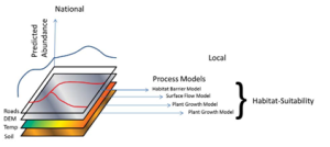
 The overall impression gained is that there is increasing need for understanding possible future scenarios from planning agencies at the local through to national scale and for a wide range of time scales.
Many practical models have been identified which could meet these needs, be that in understanding complex bio-physical feedback mechanisms or communicating risk and involving stakeholders in planning responses.
While many have made the cost-benefit case of models, there is non-the-less an upfront cost in time and data. This is particularly so for more complex models and those offering stakeholder involvement. Education is needed not just for those running models, but also those commissioning work, directing national and local dataset development and the general public. Organisational aspects might help reduce this opportunity-cost ratio as will longer term capacity building e.g.:
- Fostering a national network for applied environmental modelling, connecting research, and practice and government agencies.
- Fostering regional networks, including Higher Education bodies, regional government and Länsstryelsen, to share skills, tools and experience in model downscaling and optimisation methods.
- Development of local “hubs” to support complex modelling for priority processes.
- The removal of financial and intellectual property barriers between public agencies and public data.
- Identifying priority processes in strategic and local planning where modelling is needed and issuing a call to develop specific workflows, guidance, tools and data for this.
- Supporting national standards and tools to help municipalities spatially index all their planning related documents and data.
- Initiating a program of education and support to encourage municipalities and regional authorities to prioritise training entire teams on how models may be built into their decision making (i.e. planners and environmental officers not only the GIS specialists) and looking at workflows to facilitate use of modelled scenarios.
